- Kalendarium
-
Debaty
- Czy Polska będzie "Fit for 55%"?
- Efektywność energetyczna i odnawialne źródła energii w budynku wielorodzinnym
- Gospodarowanie wodą w budynku wielorodzinnym
- Jak przeciwdziałać ubóstwu energetycznemu i zanieczyszczeniom powietrza
- Szanse rozwoju energetyki morskiej w Polsce
- E-mobility – czy tylko samochód elektryczny?
- Zielone finansowanie
- Gospodarka o obiegu zamkniętym
- Czy planowanie przestrzenne w Polsce da się naprawić?
- Czy transformacja energetyczna w Polsce oznacza wzrost bezrobocia?
- Roślinność na wokół i w budynku wielorodzinnym
- Fundusze unijne na gospodarkę niskoemisyjną
- Ekologia w modzie i tekstyliach
- Seminarium naukowe: Co ekstremalne zjawiska pogodowe mówią nam o zmianach klimatu?
- Woda w mieście - jak ją zagospodarować
- Senior czuje dobry klimat
- Przyszłość ciepłownictwa w Polsce
- Jak zmniejszyć ubóstwo energetyczne?
- Jak osiągnąć neutralny dla klimatu transport w ciągu najbliższych 30 lat?
- Jaki rynek pracy po węglu?
- Czy polska gospodarka może działać bez węgla?
- Jaką energetykę warto dotować?
- Dlaczego węgiel tanieje?
- Zielone miejsca pracy
- Miasto bez samochodu?
- Śląsk - co po węglu?
- Ustawa o energetyce odnawialnej
- Ile powinien kosztować prąd
- Szczyt klimatyczny w Limie
- Węgiel a zdrowie
- Efektywność szansą dla gospodarki
- Energetyka rozproszona
- Polska wobec celów 2030
- Biblioteka
- Wideo
- Patronaty
- Projekty
- O serwisie
- Opinie
- Polityka klimatyczna
- Nauka o klimacie
- Zielona gospodarka
- Inicjatywy lokalne
- Energetyka
- Transport
- ADAPTACJA
- PARYŻ COP21
więcej
Polityka klimatyczna
Nauka o klimacie
Zielona gospodarka
Inicjatywy lokalne
Energetyka
Climate changes
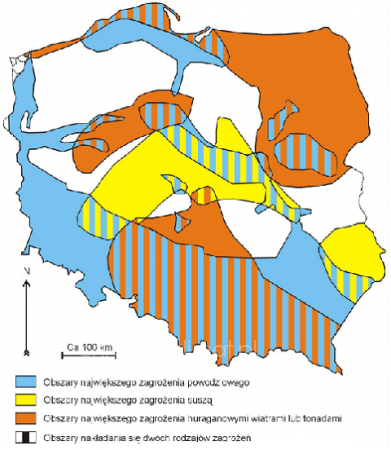
Areas most vulnerable to the occurrence of catastrophic weather phenomena associated with climate change in Poland

Translation of the Map Legend:
- areas of greatest flood risk
- areas of greatest drought risk
- areas of greatest risk of hurricane winds or tornadoes
- the overlap of the two types of threats
The Map is based on Climatic Water Balance of Poland for the period 1.04.2007-30.09.2007, multiyear observations of Institute of Meteorology and Water Management and internet website www.twojapogoda.pl
Map does not show areas endangered by rising sea level (Żuławy, Neighbourhood of Zalew Szczeciński, Mierzeja Wiślana and Mierzeja Helska) and diminishment of snowfall (mountain areas in the South Poland).
Tłum. Katarzyna Sołdaczuk
Za treść materiału odpowiada wyłącznie Fundacja – Instytut na Rzecz Ekorozwoju


Newsletter
Patronaty
Kalendarium
- PN
- WT
- ŚR
- CZ
- PT
- SO
- ND
Warning: Illegal string offset 'dzien' in /tpl_c/%%58^58D^58DE6355%%kalendarz.tpl.php on line 31
0
Warning: Illegal string offset 'dzien' in /tpl_c/%%58^58D^58DE6355%%kalendarz.tpl.php on line 31
0- 1
- 2
- 3
- 4
- 5
- 6
- 7
- 8
- 9
- 10
- 11
- 12
- 13
- 14
- 15
- 16
- 17
- 18
- 19
- 20
- 21
- 22
- 23
- 24
- 25
- 26
- 27
- 28
- 29
- 30
- 31
 |
ChronmyKlimat.pl wersja 2.0 – portal na temat zmian klimatu dla społeczeństwa i biznesu. © Copyright Fundacja Instytut na rzecz Ekorozwoju |
| Redakcja: ul. Nabielaka 15 lok. 1, 00-743 Warszawa, tel. +48 +22 8510402, -03, -04, fax +48 +22 8510400, portal@chronmyklimat.pl |
RSS
Polityka prywatności


